

Conservation Easement contact:
Destiny McDonald
Easement Coordinator
Phone - (320) 631-3558

Easement Programs
ARMY COMPATIBLE USE BUFFER (ACUB)
Federally funded easements are working lands easements that allow continued farming, hunting, and normal agricultural activities. Funded by the Department of Defense (DOD), these easements are located in priority one and two areas around Camp Ripley: priority one being closest to the base and most critical for protecting training operations.
In 2001, the National Guard Bureau began addressing development and encroachment around Camp Ripley. In 2004, it partnered with the State of Minnesota, through the Board of Soil and Water Resources (BWSR), to implement the Army Compatible Use Buffer (ACUB) program. Camp Ripley is a 53,000-acre regional training center with extensive facilities supporting military and civilian training.
The ACUB program limits intensive residential and commercial development by purchasing development rights through permanent conservation easements. Landowners receive a one-time payment per acre to keep their land undeveloped but may continue current agricultural or recreational uses. Participation in the program is voluntary.
Morrison SWCD works with Camp Ripley Training Center (CRTC) and BWSR to carry out easements in Morrison, Crow Wing, and Cass Counties. Each year, CRTC ranks and prioritizes parcels for possible funding. A “Short List” of eligible landowners is provided to the SWCD to work with as funding becomes available.
Once completed, easements are permanent, and SWCDs monitor enrolled lands to ensure compliance with easement terms.
Landowners interested in participating in the program can print, complete, and submit a Landowner Interest Form (this link is not to the current fillable form document) to Morrison Soil and Water Conservation District.
LESSARD-SAMS OUTDOOR HERITAGE COUNCIL
In 2011 the ACUB program received its first state appropriations from the Outdoor Heritage Fund, which allowed for easements within an expanded 5-mile radius of the base. These state funded easements are habitat focused, and as such, are more restrictive than the federally funded easements.
These easements are designed to address specific resource needs and landowner desires on their property. The main restrictions for LSOHC ACUB easements are:
-
No cropping, haying and/or grazing
-
No harvesting large amounts of trees unless approved by BWSR with a forest stewardship plan
-
Forfeiture of building and sub-development rights
-
No mining activities
-
No placement of wells and sewage disposal systems
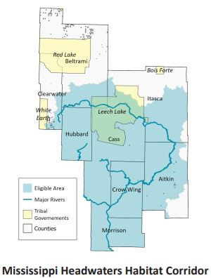
MISSISSIPPI HEADWATERS BOARD
In 2016, the Mississippi Headwaters Board partnered with the Board of Water and Soil Resources and The Trust for Public Land to protect important fish and wildlife habitats on private lands along the Mississippi River, headwater lakes, reservoirs, and tributaries. Using Outdoor Heritage Funds from the Clean Water, Land, and Legacy Amendment, the program creates and expands permanently protected shoreland and connected habitat complexes.

Conservation easements are voluntary, permanent legal agreements that perpetually protect land for future generations by limiting certain uses while keeping it in private ownership.
The Minnesota Board of Water and Soil Resources (BWSR) acquires these easements on behalf of the state to permanently protect, restore, and manage critical natural resources. Landowners retain ownership and responsibility for maintenance, taxes, and assessments. Their property remains private and not open to the public.
BWSR oversees statewide coordination, while local Soil & Water Conservation Districts (SWCDs) handle implementation. Landowners receive payment for the restricted land-use rights, and the easement is recorded with the county. These easements are perpetual and transfer with the property upon sale.